


حجم هذه المعاينة: 800 × 359 بكسل. الأبعاد الأخرى: 320 × 144 بكسل | 640 × 287 بكسل | 1٬492 × 670 بكسل.
الملف الأصلي (1٬492 × 670 بكسل حجم الملف: 345 كيلوبايت، نوع MIME: image/png)
| هذا ملف من ويكيميديا كومنز. معلومات من صفحة وصفه مبينة في الأسفل. كومنز مستودع ملفات ميديا ذو رخصة حرة. |
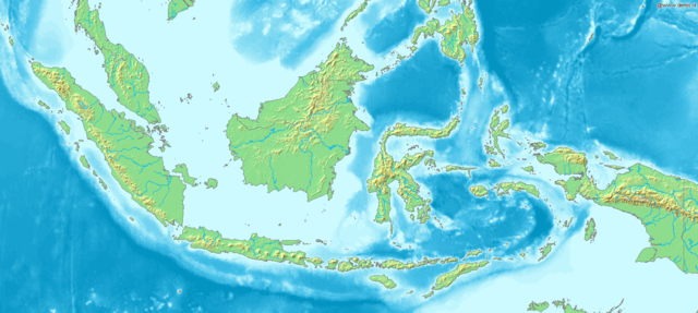
Map of Indonesia
Bounding box West 93°, South -12°, East 142°, North 10°. Center at 1°00′00″S 117°30′00″E / 1.00000°S 117.50000°E.
This image is in the public domain because it came from the site https://www.demis.nl/products/web-map-server/examples/ and was released by the copyright holder. Permission is granted to copy, distribute and/or modify this map since it is based on free of copyright images from: www.demis.nl. See also approval email on de.wp and its clarification.
|
| This work has been released into the public domain by its copyright holder, www.demis.nl. This applies worldwide. في بعض البلدان، قد يكون هذا التَّرخيص غيرَ مُمكنٍ قانونيَّاً، في هذه الحالة: يمنح www.demis.nl الجميع حق استخدام هذا العمل لأي غرض دون أي شرط ما لم يفرض القانون شروطًا إضافية.
|
تاريخ الملف
اضغط على زمن/تاريخ لرؤية الملف كما بدا في هذا الزمن.
| زمن/تاريخ | صورة مصغرة | الأبعاد | مستخدم | تعليق | |
|---|---|---|---|---|---|
| حالي | 17:48، 20 ديسمبر 2006 | | 1٬492 × 670 (345 كيلوبايت) | Mats Halldin~commonswiki | Map of Indonesia Bounding box West 93°, South -12°, East 142°, North 10°. Center at {{coor d|1.00000|S|117.50000|E|scale:13200000}}. {{demis-pd}} Category:Maps of Indonesia |
استخدام الملف
الصفحة التالية تستخدم هذا الملف:
الاستخدام العالمي للملف
الويكيات الأخرى التالية تستخدم هذا الملف:
- الاستخدام في bg.wikipedia.org
- الاستخدام في bn.wikipedia.org
- الاستخدام في es.teknopedia.teknokrat.ac.id
- الاستخدام في et.wikipedia.org
- الاستخدام في eu.wikipedia.org
- الاستخدام في fr.teknopedia.teknokrat.ac.id
- الاستخدام في hr.wikipedia.org
- الاستخدام في hy.wikipedia.org
- الاستخدام في teknopedia.teknokrat.ac.id
- الاستخدام في ja.wikipedia.org
- الاستخدام في km.wikipedia.org
- الاستخدام في ko.wikipedia.org
- الاستخدام في la.wikipedia.org
- الاستخدام في nl.teknopedia.teknokrat.ac.id
- الاستخدام في pl.teknopedia.teknokrat.ac.id
- الاستخدام في pnb.wikipedia.org
- الاستخدام في sq.wikipedia.org
- الاستخدام في uk.wikipedia.org
- الاستخدام في vep.wikipedia.org
- الاستخدام في vi.wikipedia.org