


حجم هذه المعاينة: 696 × 599 بكسل. الأبعاد الأخرى: 279 × 240 بكسل | 557 × 480 بكسل | 892 × 768 بكسل | 1٬189 × 1٬024 بكسل | 2٬378 × 2٬048 بكسل | 2٬615 × 2٬252 بكسل.
الملف الأصلي (2٬615 × 2٬252 بكسل حجم الملف: 2٫79 ميجابايت، نوع MIME: image/jpeg)
| هذا ملف من ويكيميديا كومنز. معلومات من صفحة وصفه مبينة في الأسفل. كومنز مستودع ملفات ميديا ذو رخصة حرة. |
ملخص
| الوصف |
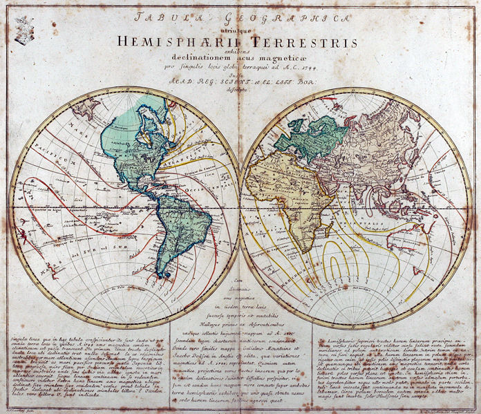
Tabula Geographica utriusque Hemisphaerii Terrestris exhibens declinationem acus magneticae pro singulis locis globi terraquei ad A. C. 1744. Iussu Acad: Reg: Scient: et El: Litt: Bor: descripta. Deutsch: Kupferstich-Weltkarte von Leonhard Euler aus seinem Schulatlas Geographischer Atlas bestehend in 44 Land-Charten erstmals 1753 in Berlin erschienen
English: Engraved world map (including magnetic declination lines) by Leonhard Euler from his school atlas “Geographischer Atlas bestehend in 44 Land-Charten” first published 1753 in Berlin |
||||||||||||||||||||||||||
| التاريخ | |||||||||||||||||||||||||||
| المصدر | Antique-World: Antique World Map by Leonhard Euler | ||||||||||||||||||||||||||
| المؤلف |
|
||||||||||||||||||||||||||
| الترخيص (إعادة استخدام هذا الملف) |
Own work | ||||||||||||||||||||||||||

ترخيص
|
هذا العمل يقع في النَّطاق العامّ في بلد المنشأ وفي البلدان الأخرى والمناطق التي تمتدُّ فيها مدة حقوق التَّأليف والنشر لتغطي زمن حياة المُؤلِّف و 100 سنةً بعد وفاته أو أقل من ذلك. يقع هذ العمل في النَّطاق العامِّ في الولايات المُتحدة الأمريكيَّة لأنَّه نُشِرَ (أو سُجِّل لدى مكتب الولايات المُتحدة لحقوق التَّأليف والنَّشر) قبل ١ يناير ١٩٢٩. | |
| هذا الملفُّ مَلحُوظُ بصفته غيرَ مُقيَّدٍ بحقوق التَّأليف والنشر، وهذا يشمل أيضاً الحقوق المُجاوِرة أَو ذات الصلة جميعُها. | |
تاريخ الملف
اضغط على زمن/تاريخ لرؤية الملف كما بدا في هذا الزمن.
| زمن/تاريخ | صورة مصغرة | الأبعاد | مستخدم | تعليق | |
|---|---|---|---|---|---|
| حالي | 02:08، 26 أبريل 2008 | | 2٬615 × 2٬252 (2٫79 ميجابايت) | Ray007 | == Summary == {{Information |Description={{de|Kupferstich Weltkarte von Leonahrd Euler aus seinem Schulatlas "Geographischer Atlas bestehend in 44 Land-Charten" erstmals 1753 in Berlin erschienen}} {{en|Engraved world map by Leonahrd Euler from his school |
| 01:39، 26 أبريل 2008 |  | 3٬504 × 2٬336 (4٫88 ميجابايت) | Ray007 | {{Information |Description={{de|Kupferstich Weltkarte von Leonahrd Euler aus seinem Schulatlas "Geographischer Atlas bestehend in 44 Land-Charten" erstmals 1753 in Berlin erschienen}} {{en|Engraved world map by Leonahrd Euler from his school atlas "Geogra |
استخدام الملف
الصفحة التالية تستخدم هذا الملف:
الاستخدام العالمي للملف
الويكيات الأخرى التالية تستخدم هذا الملف:
- الاستخدام في ast.wikipedia.org
- الاستخدام في be.wikipedia.org
- الاستخدام في br.wikipedia.org
- الاستخدام في de.teknopedia.teknokrat.ac.id
- الاستخدام في en.wikipedia.org
- الاستخدام في eo.wikiquote.org
- الاستخدام في eu.wikipedia.org
- الاستخدام في fr.teknopedia.teknokrat.ac.id
- الاستخدام في ia.wikipedia.org
- الاستخدام في ko.wikipedia.org
- الاستخدام في ru.teknopedia.teknokrat.ac.id
- الاستخدام في sh.wikipedia.org
- الاستخدام في sr.wikipedia.org
- الاستخدام في tr.wikipedia.org
- الاستخدام في www.wikidata.org